Since the union of Crimea with Russia in March 2014, the entry into the sea of Azov is fully controlled by Russia.
The following article is a revised and update of an earlier GR article by Michel Chossudovsky It provides a brief summary of the Geopolitics of the Black Sea and the Sea of Azov as well as some observations on the Ukraine War. (Updated on June 5, 2022)
Written by Prof Michel Chossudovsky. Originally published on GlobalResearch
Introduction
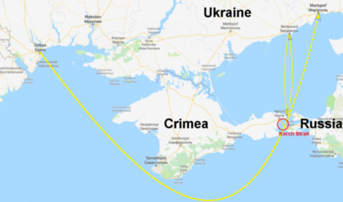
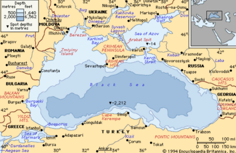
Historically, the Kerch strait in Eastern Crimea has played a strategic role.
It constitutes a narrow maritime gateway which links the Black Sea via the Sea of Azov to Russia’s major waterways including the Don and the Volga.
It also ensures maritime transit from the Black Sea to Moscow not to mention the strategic maritime route between the Caspian Sea (via the Volga-Don Canal) to the Black Sea and the Mediterranean.
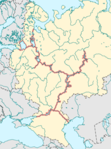
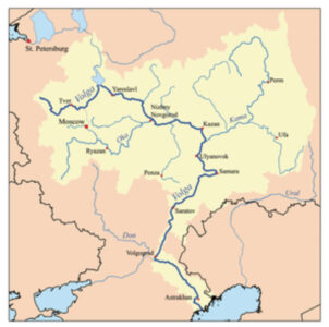
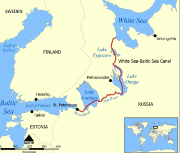
The Volga also links the Caspian Sea to the Baltic Sea as well as to the Northern Sea route, via the Volga–Baltic Waterway. (See above)
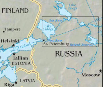
The Volga is connected to a system of canals (via lakes Onega, Ladoga) to the Neva River and St Petersburg. (See map below)
What is at stake is an integrated system of waterways which connects the Black Sea and the Caspian Sea to the Baltic and the Northern Sea Route.
In this regard the narrow Kerch Strait in Eastern Crimea is strategic.
The 2014 Union of Crimea with Russia Redefines the Geography and the Geopolitical Chessboard of the Black Sea Basin
Since 2014, the reunion of Crimea to the Russian Federation, represented a major setback for US-NATO, whose longstanding objective was to integrate Ukraine into NATO, while extending Western military presence in the Black Sea basin. (See details below)
Brief Observations on the Ukraine War: The Sea of Azov is Strategic. Ukraine Has No Maritime Access.
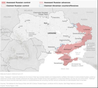
In regards to the Ukraine War, Russia’s control of the Kerch Strait plays a key role. In recent developments (June 2022), Russia now controls the entire basin of the Sea of Azov.
Ukraine has no maritime access to the Sea of Azov and Eastern Ukraine, nor does it have naval power in the Black Sea.
Without a navy, Ukraine is not in a position to win this war. The Peace Negotiations initiated in Istanbul in late March, which were the object of sabotage constitute the only solution.
Ukraine’s Naval Base Berdyansk (a 2020 initiative of Zelensky) on the Western Azov coastline is under Russian control. All major ports extending from Mariupol to Kherson are under Russian control.
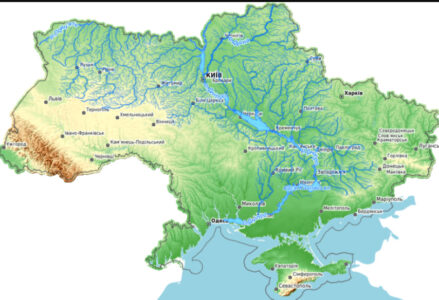
Russia occupies Kherson and controls the access of Ukraine’s major river-way the Dnieper to and from the Black Sea (see second map below: The Dnieper is in some regards a seaway.) The Dnieper is a major corridor of grain cargo transportation.
In the context of the Ukraine War, through their military deployments in Donetsk and Lugansk, Russian forces have consolidated their control over the entire Sea of Azov basin.
The map below (June 2, 2022) indicates the areas of deployment and Russian control from the North of Lugansk (territories opposite Kharkov) to Kherson on the Dnieper.
Flashback: The 2014 Treaty between Russia and Crimea
With the March 18, 2014 Treaty signed between Russia and Crimea, the Russian Federation has extended its control over the Black Sea as well as over the Sea of Azov.
Under the agreement between Russia and Crimea announced by president Putin in 2014, two “constituent regions” of Crimea joined the Russian Federation: the “Republic of Crimea” and the “City of Sevastopol”. Both have the status of “autonomous regions”. The status of Sevastopol as an autonomous entity separate from Crimea is related to the location of Russia’s Naval base in Sevastopol.
Since the break-up of the Soviet Union, Russia retained its naval base in Sevastopol under a bilateral agreement with Ukraine. With the signing of the March 18th 2014 Treaty, that agreement became null and void. Sevastopol including the Russian naval base became part of an autonomous region within the Russian Federation. Prior to March 2014, the naval base was not within Ukraine under a lease agreement. Moreover, since 2014, Crimea’s territorial waters belong to the Russian Federation.
Following the union of Crimea to Russia, The Russian Federation now controls a much larger portion of the Black Sea, which includes the entire coastline of the Crimean peninsula. The Eastern part of Crimea –including the Kerch strait– are under Russia’s jurisdiction. On the Eastern side of the Kerch strait is Russia’s Krasnodar region and extending southwards are the port cities of Novorossiysk and Sochi.
The Geopolitics of Oil and Gas Pipelines
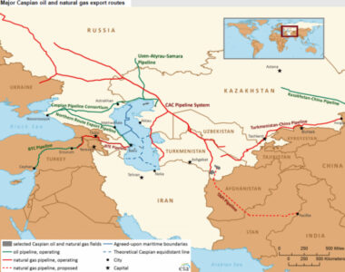
Novorossiysk is also strategic. It is Russia’s largest commercial port on the Black Sea, at the cross-roads of major oil and gas pipelines between the Black Sea and the Caspian sea.
While the main strategic oil pipeline route is between Novorossiysk and Baku, there is a nexus of gas pipelines between Russia, Kazakhstan, Iran, Turkmenistan, linking up with China.
Prior to Russia’s “invasion” of Ukraine on February 24, 2022, Putin signed “a wide-ranging agreement” with the president of Azerbaijan Ilham Aliyev.
Kerch Strait: History
Historically, the Kerch strait has played a strategic role. It constitutes a gateway from the Black Sea to Russia’s major waterways including the Don and the Volga.
During World War II, the Kerch peninsula was occupied by Nazi Germany (taken back by the Red Army) was an important point of transit by land and water.
In the coldest months of Winter, it became an ice bridge linking Crimea to the Krasnodar region.
The Kerch strait is about 5 kilometers in length and 4.5 km. wide at the narrowest point between the tip of Eastern Crimea and the peninsula of Taman. Kerch is a major commercial port linked to railway, ferry and river routes.
image right: Kerch strait, photo taken from Crimean side, (prior to the construction of the bridge) narrow width, aerial view of strait and Taman peninsula.
The Sea of Azov: Geopolitical Hub
Of significance, as a result of the integration of Crimea into the Russian Federation in 2014 Moscow gained full control of the Kerch Strait linking the Black Sea to the Sea of Azov. The bilateral agreement between Russia and Ukraine governing the maritime route through the Kerch straights was scrapped.
The strait also constitutes an entry point into Russia’s major river waterways.
The Sea of Azov connects with the Don River and the Volga, through the Volga Don Canal. In turn, the Volga flows into the Caspian sea.
The Kerch strait is strategic. The Kerch-Yenikalskiy Canal allows large (ocean) vessels to transit from the Black Sea to the Sea of Azov.
As outlined above, the Kerch Strait links the Black Sea to the Volga via the sea of Azov and the Volga Don Canal which in turn connects to Saint Petersburg and the Baltic Sea. The Volga also connects to Moscow, via the Moscow river through the Volga-Moskva canal.
Note: The Caspian sea basin is in sense “landlocked”. It’s only access to the Mediterranean and the Atlantic Ocean is via the Volga. The same applies to its access to the Atlantic via the Baltic Sea, or via the White Sea, the Barents Sea and the Northeast Arctic Passage to the Pacific.
Strategic waterways. In Summary
- Caspian Sea- Volga, Volga-Don Canal, Don, – Sea of Azov -Black Sea, Mediterranean
- Black Sea- Sea of Azov -Don- Volga Don Canal -Volga -Volga-Moskva Canal, Moscow River, Moscow
- Black Sea- Sea of Azov -Don- Volga Don Canal -Volga -Neva, St Petersburg, Baltic Sea
- Caspian Sea, Volga, Neva, Svir, Onega Lake, White Sea Canal, North Sea and Northeast Arctic Passage
Russia-Ukraine Relations Regarding the Kerch Strait
In December 2013, Moscow signed a bilateral agreement with the Yanukovych government in Kiev pertaining to the construction of a bridge across the Kerch Strait, connecting Eastern Crimea (which was part of Ukraine) with Russia’s Krasnodar region.
That agreement was a followup to an initial agreement signed in April 2010 between the two governments.
The Russia-Ukraine 2013 agreement pertaining to the construction of the bridge had, for all purposes already been scrapped before March 16, 2014.
Image right: new Kerch bridge links Eastern Crimea (road and rail transportation) to Russia’s Krasnodar region. (image right).
Crimea’s union to Russia was already in the pipeline prior to the referendum, it was a fait accompli.
Less than two weeks before the March 16 2014 Referendum, at the height of the crisis in Ukraine, Russia’s Prime Minister Dmitry Medvedev ordered the state-road building corporation Avtodor, or “Russian Highways” “to create a subsidiary company that would oversee the building of a bridge across the Kerch Strait”.
This bridge is geared towards train transport routes linking Western and Eastern Europe to the Caspian Sea basin, Kazakhstan and China. It is therefore an integral part of the Eurasian Project (linking up with China’s Belt and Road initiative).




“strategic”
The second map show the far-sighted logic of the Moscow Peace Treaty where Finland ceded 9% of its territory as regards waterways–look at the border line and its to Russia,s advantage.
Rump Ukropland, after the Polaks slice off the naZi west, will be a landlocked island surrounded by Russia, no access to sealanes and a much quieter and friendlier place for all.
Onward to Odessa, Russian territory since 1792.
Well said
Superb article. Well written.