0 $
2,500 $
5,000 $
100 $
NOVEMBER 2024

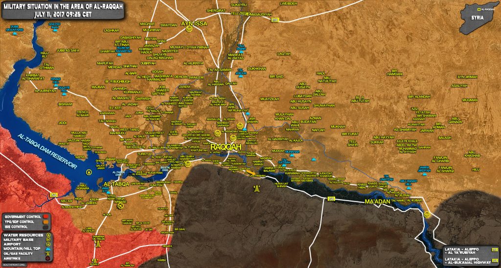
US-backed Forces Resume Advance In Southern Raqqah Countryside (Map Update)

Support SouthFront

The US-backed Syrian Democratic Forces (SDF) recaptured the village of Ukayrishah from ISIS in the southeastern Raqqah countryside.  The SDF is slowly moving along the Euphrates River capturing villages located near the road to Deir Ezzor. The goal of these efforts is to set conditions for an expected operation against ISIS in the Deir Ezzor countryside.

US-backed Forces Resume Advance In Southern Raqqah Countryside (Map Update)

Click to see the full-size map

Support SouthFront

SouthFront

Subscribe
Notify of
guest
18 Comments
Oldest
Newest Most Voted
Inline Feedbacks
View all comments
mhtsaropinigitakis

what? did they capture the whole city already?

Jens Holm

My comment to hendrik. Its a borderquestion among SDF & SAA and not an about ISIS map. Thats how I see it.

If You want better – but filled with fakes and shit – You can use liveupdate.map for syria.

John Marks

This was entirely predictable. SAA need to secure the right bank of the Euphrates and the N4 Raqqa – DeZ road.

Hendrik

I think the map is wrong with regards to Raqqa.

Jens Holm

Yes, seems hard to update correct. In liveupdate.maps. there are many which are not to rely. Its mixed up.

I think You should take the map here for, what its about. Its the borderlines and possibilities for SAA & SDF and not about ISIS having 9 or 5 km2 in Raqqa.

Barba_Papa

As I said, the SAA needs to reach the Euphrates river ASAP and spend less time on ISIS in Eastern Hama. Yes, ISIS in this area is troublesome, but they will be easier to dislodge later on then the SDF and the US military will be along the Euphrates if they get there first.

Justin Ryan

SAA are going to close off Eastern Hama! Then make a 200km wide front against ISIS to spread ISIS forces thin! Then make a breakthrough run from anywhere within this 200km frontline spread! One day u will wake up and see that the SAA made a 100km dash to the Euphrates and Deer Ezoir! They don’t need to reach Deir Ezoir, they only need to cut off the SDF!

Bertharkoss

our best friend’s step-mother makes $73 an hour on the laptop and she has been unemployed for 8 months but last month her income was $21714 just working on the internet for a few hours each week.➤ see➤ this page ➜➜➜http://www.GoogleFinancialCashJobs482ShopTag/Home/Wage…. ✔✔✔✔✔✔✔✔✔✔✔✔✔✔✔✔✔✔✔✔✔✔✔✔✔✔✔✔✔✔✔✔✔✔✔✔✔✔✔✔✔✔✔✔✔✔✔✔✔✔✔✔✔✔✔✔::::an92..

telefonkabel

Recaptured? Had SDF captured it already in the past? (I really don’t know, perhaps ISIS did a counteroffensive there in the last weeks)

Graeme Rymill

The SDF presumably want the northern side of the Euphrates as their border. Why would they advance on the southern side of the river to Deir Ezzor? If they lifted the siege from the south side they would still have the SAA holding the southern part of Deir Ezzor. How would that play out? The SDF are not seeking direct confrontation with the SAA.

These attacks are more likely to be for local tactical reasons than part of some wider strategic plan.

Jens Holm

I agree. Right now SDF are advancing east of Tabqa to make Raqqa 200% closed and deny ISIS to make counterattacs.

I think its fine SAA give SDF space for killing ISIS.

Too many here make total wrong assumptions all the time.

dutchnational

If the SDF had wanted to go onwards to DeZ, they could have taken the ponton bridge even though damaged, right at the east end of their lines.

But maybe objectives have changed. One can see why the US would want to have DeZ taken by other then IS and SAA.

Graeme Rymill

There are 4 possible routes for the SAA to get to Deir Ezzor. A central route via As Sukhnah A southern route via T2 pumping station and then a left turn at the Euphrates to head north Two northern routes: From Resafa head towards Highway 4 and then south along the Euphrates From Resafa head inland via Mount Bishri and emerge at Deir Ezzor.

Which route will the SAA choose? Perhaps they will try simultaneous advances along several of them. The routes along the Euphrates either from the north or south could prove the hardest. The fertile Euphrates River valley is covered with little towns and villages and vegetation that make for good defensive positions for Islamic State. The As Suknnah route always looked the most promising but progress has been glacial. The mountainous geography has been suggested as a cause. Most of the videos I see show a flat desert.

Solomon Krupacek

all should

Jens Holm

Well, try Michelin map. You will see low real mountains from Palmyra to Sukna and more. They map type You use is “outdoors”.

I mainly used Michelin for Tabqa and the dam areas to see how ISIS defended it well and SDF advanced well and got several surprices.

RamboDave

This is only an advance of about 2 miles. This is not a real story to be concerned with. For the last year the YPG/SDF line has been very quiet from Raqqa Eastward along the Euphrates river. They have no intention to go South.

On the other hand, the real story is the airlifting of the FSA and the new US base at al Shaddadi, North of Deir el Zor. That is what worries me.

David Wadström

Wow, look at all the desktop generals. I belive the Syrians are experienced enough to deal with the situation, after 6 years of fighting foreign mercenaries. Praise to the martyrs of the proud SAA!

markusaa

SDF and USA is the one fighting ISIS. SAA focus on torturing civilians as they always did. Hopefully Russia and Iran get tired on Assad

18
0
Would love your thoughts, please comment.x
()
x